|

Sample Plans 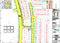
| Services Consultant in Land and Housing Development Submission of application to related government institution and agencies such as Pejabat Tanah, Majlis Daerah, Jabatan Perancang Bandar, Pejabat Tanah dan Galian etc. of the following : - Application of Land
- Surrender of Land (Partial or Whole)
- Surrender and Re-Alienation
- Variation of Express Condition and Restriction in Interest
- Simultaneous Subdivision and Variation of Express Condition
- Subdivision
- Partition
- Amalgamation
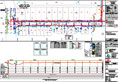
Cadastral Survey - Land Title Survey and Strata Title Survey - Carrying out Land Title Survey and submission of Certified Plan to Survey Department
- Carrying out Strata Title Survey and submission of Strata Application Plan and Strata Certified Plan to Survey Department
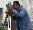
Topographical and Engineering Survey - Topographical, Detail and Site survey
- Boundary, Right of Way, Reserve, Land Acquisition and Boundary Demarcation survey
- Setting Out and As-built survey of building, piles, earthwork, borehole etc.
- Topographical, route, profile, cross section, centreline setting out and as-built survey of the following job:
- Road
- Water Pipeline
- Waterworks
- Railway
- TNB Transmission Line
- Gas Pipeline
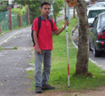
Data Conversion Conversion of hardcopy map/plan by scanning and digitizing. Output can be in various forms of maps, plans or digital data. Underground Utilities Detection and Mapping Detect, survey and map underground utilities such as cable, pipe, gas, telecommunication etc. using Radio Detection method. Hydrographic Survey Topographical (onshore) profiling, bathymetric (offshore) profiling, tidal observation, current measurement, seawater temperature & salinity measurement, seabed (grab) soil sampling, seawater sampling etc. Point Positioning Survey using Global Positioning System (GPS) - Setting-up network of control points
- Real Time Kinematic survey
- GIS data collection
Geographical Information System (GIS) - A system capable of integrating, storing, editing, analyzing, sharing, and displaying geographically-referenced information
Aerial Photography and Remote Sensing - Aerial photographs, diapositive, photo mosaic etc for project planning and analysis
- Landsat, Spot, Radarsat, Quickbird, Ikonos remote sensing satellite data from MACRES for analysis
|